by: Historic St Augustine Preservation Board
Florida Master Site File
Historic Properties Inventory Form
SECTION IV:
SIGNIFICANCE:
Areas of Significance: Architecture, Famalies, Minorcans, Commerce.
ARCHITECTURE:
This two-story Frame Vernacular residence at 63 Marine Street was constructed between 1865 and 1885. The second floor balcony consists of a decorative railing of a criss-cross design winch was popular on Territorial Period (1821-1845) buildings. The butt cut cedar shingle exterior and contrasting belt course are similar to a turn of the century construction style. The house appears on the 1885 Birds-Eye View and the 1893 Sanborn Fire Insurance Map; however, neither deed research nor on-site inspection produced evidence of pre-Civil War construction. The house set on coquina piers is near the street line on a narrow street in one of the oldest sections of town.
The area of the colonial city between Bridge and St. Francis Streets is one of mixed usages. Though primarily residential, it includes commercial tourist attractions, religious, and educational buildings. The narrow streets, some still brick, conform to the colonial town plan listed on the National Register of Historic Places. Construction dates in the area range from colonial through modern times. Many of St. Augustine’s surviving colonial buildings are located along Marine and St. Francis Streets, including the Oldest House. Along the bayfront and on St. George Street are two of the outstanding Victorian neighborhoods of the city, with many elegant winter residences from the Flagler era. Some colonial-style buildings have been reconstructed, and other buildings have been remodeled in the St. Augustine Colonial Revival style. The area is bounded on the west by Cordova Street and on the east by the bayfront. The section of Avenida Menendez between Bridge and St. Francis is the major waterfront residential street of the downtown area. The area has suffered many demolitions for parking lots and expanded school grounds over the years. A heavy toll has been taken among Flager-era buildings. The area continues to feel pressure from the large amount of tourist and school traffic that passes through.
HISTORY
This section of the walled colonial city was first occupied in the 17th century as the early settlement expanded south towards the St. Francis convent. All structures were destroyed in 1702 by the invading South Carolinians, but by mid-century, houses had been rebuilt on all streets except present-day Cordova Street, then the course of the early 18th century Rosario defense line. The northern boundary of the area, Bridge Street, led to one of three late colonial San Sebastian River ferry crossings. The British demolished numerous buildings here, but were the first to build along the bayfront on the east side of Marine Street. The Spanish filled this lowlying land in the 1790’s, and substantial residences were thereafter erected on the reclaimed land. The Spanish crown owned considerable property in this section of the colonial city, such as a school building near the southeast corner of Bridge and St. George Streets and the vacant land west of St. George Street where crops were raised by the garrison. Nine colonial buildings have survived in this section, particularly in clusters along Marine and St. Francis Streets: Sanchez, Mann, Piiello, Jones and the two Rovira Houses on Marine; Tovar and Oldest House on St. Francis; and the St. Francis Inn on corner of St. George and St. Francis. The Llainbias House and the St. Francis Barracks lie on the south side of St. Francis Street.(1) The area remained essentially residential throughout the American period, although several religious structures were built along St. George Street (the nonextant 19th century Presbyterian Church and the 20th century Cathedral Parish School complex) and along Cordova Street (the 20th century Synagogue). Several boarding houses were scattered throughout the area, most notably the St. Francis Inn building and the Valencia Hotel. Taken as a whole, this section has a high concentration of 18th and 19th century buildings on all streets except Cordova which was developed primarily in the 1920’s.(2)
Early residents of this house included members of the Leonardi and Masters families. Both families descend from colonists who migrated to St. Augustine from New Smyrna in 1777: the Leonardi family from Italy, the Masters from Menorca. Occupants include Norman Leonardi, a carpenter; Flora; the widow of C. J; and Douglas C., a salesman for Pilgrim Shoe Store. Of the Masters family, Reuben C., a clerk with Burton L. Masters, resided in tile house.(3)
ARCHAEOLOGY
For archaeological significance of the walled colonial city see Master Site File Form 8SJ1O.
BIBLIOGRAPHY
1. Kathleen Deagan, at. al, “A Sub-Surface Survey of the St. Augustine City Environs,” (Tallahassee, 1976); Juan Jose Ellxio de la Pucitte, “Piano de la Plaza de San Agustin,” January 22, 1764; Nariano de la Rocque, “Piano Particular de la Ciudad de San Agustin,” April 25, 1788; East Florida Papers, Escrituras, 1784-1821; Albert Manucy, The Houses of St. Augustine 1565-1821 (St. Augustine, 1962), pp. 22-25 and 41-47.
2. Anon., “Copy of a Plan of the City of St. Augustine,” 1833; 1885 and 1894 Birds-Eye Views; Sanborn Fire Insurance Maps, 1888-1958.
3. St. Augustine City Directory, 1920-21, 1924-25,1934.
Other Resources
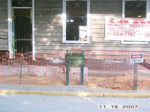
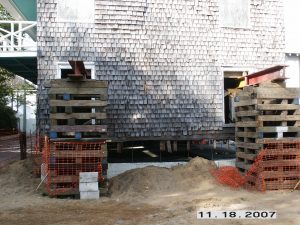
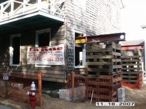
The house was Restored/Rehabilitated between 2007 and 2009. Here are some photos of the work in progress and the City’s notes on that.


CITY OF ST. AUGUSTINE, FLORIDA
Regular Code Enforcement, Adjustments and Appeals Board Meeting July 10, 2007
The Code Enforcement, Adjustments and Appeals Board met in formal session at 3:00 P.M., Tuesday, July 10, 2007, in the Alcazar Room at City Hall. The meeting was called to order by Irene Arriola, Chairperson, and the following were present:
- ROLL CALL
Irene Arriola, Chairperson Douglas A. Ferrell, Vice-Chairman Enid Hurst Robert M. Hall Patricia B. Reilly William Rosenthal
Absent: Richard W. George
Staff Present: Robin Upchurch, Esq., Assistant City Attorney Mark Knight, Director, Planning & Building Department Nick Andrade, Building Official Tom Scofield, Historic Preservation Planner Sharon O’Keefe, Administrative Coordinator
Item 4(b) 2007-0211 Elaine Darnold Inc 63 Marine Street Flood Elevation Variance City Code, Chapter 8, Section 8-401 Flood control variance.
Mr. Andrade reported the following:
- The applicant requested a variance to allow the restoration of an existing two story single family residence with a base flood elevation of 7.3 feet in the HP 1 District
- The building fronted directly on Marine Street with a Base Flood Elevation (BFE) requirement of 9 feet
- The HARB had not approved a previous request to demolish the building therefore a waiting period of one year was required prior to any demolition
- The structure was recognized by the HARB as having significant historic value
- The building was one of the last remaining houses constructed in the Federal era in the 1800’s and was in very bad shape
- The proposed rehabilitation consisted of exterior and interior work
- HARB approved certain modifications to restore the building back to its original design and footprint which included the garage
- The building would be placed on a new concrete foundation
- The main entry was at street level directly on the street right-of-way
- Elevation of the house would ruin the look and restoration that HARB was trying to accomplish
- Staff recommended approval of the variance due to the difficulty associated with the entry’s location and restrictions of the HARB, with the following findings and conditions:
Findings:
- The variance was consistent with Section 60.6 of Chapter 1 of 44 CFR (Code of Federal Regulations regarding Flooding Code variances for historical structures)
- The variance would not increase the flood hazard to this property or adjacent properties
- Granting the variance would not endanger the health, safety or welfare of the public
Conditions:
1.All new construction below the base flood elevation shall consist of flood resistant materials
2.A certificate of compliance, by a licensed Architect or Engineer, certifying that flood resistant materials and methods had been incorporated into the construction of the structure
Mr. Scofield informed the Board that the required 12 month waiting period for a demolition had expired. Therefore, the applicant could demolish the building but instead decided to rehabilitate the property.
Mr. Rosenthal asked why a garage was allowed to exist below the BFE.
Mr. Andrade explained the difference between inhabited and un-inhabited space requirements by the flood management code.
Elaine Darnold, 7 Palm Row, was sworn and stated that she agreed with staff’s recommendations. She also said she spoke for the owners of the property and was sure they would be agreeable to the conditions and findings.
Mr. Andrade used the overhead projector to show elevations of the proposed façade from each direction.
Board members commended the applicant for her plan to restore the building.
There was no public comment.
MOTION
Ms. Arriola moved to approve the variance subject to the findings and conditions recommended by staff. The motion was seconded by Mr. Rosenthal and approved by a unanimous voice vote.